The Grey Friars (Franciscan of the order Friars Minor) Monastery was founded
and erected around 1260 by Devorguilla, daughter of Allan, Lord of Galloway.
She was the granddaughter of David, Earl of Huntington who was granted the Burgh
of Dundee in around 1192 by his brother William the Lion. David went on to found
the church of St Marys. Her son John Balliol successfully competed for Scottish
crown against Robert De Brus, 5th Lord of Annandale in 1292; who in turn was the
grandfather of Robert the Bruce who went on to be crowned Robert I in 1306.
The church of the Grey Friars Monastery was the place where a grand national
ecclesiastical Council or Synod was held in 1309. In 1308 a Council of Bishops
declared Robert Bruce to be the true heir of the Crown, and by this declaration
they accepted him as their lawful King. The following year the body of the
clergy met in the church of the Minorite Friars at Dundee, on 24th February,
1309, and agreed upon, and issued a declaration in favour of Robert I.
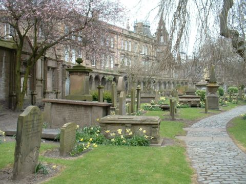
The Friary is thought have been situated at the southern part of the land now
taken up by the Howff; and to partly support this substantial foundations and a
lead pipe are said to have been discovered by sextons in the process of digging,
also it has been noted that the southern wall of the burial ground was said to
have "consisted of a low dead wall enlivened by a door which opens into the
Houff. This wall extends from the south gate of the Houff in Barrack Street a
few yards eastwards along the south side of the burying ground". Unfortunately
no further information exists. The monastery consisted of a convent, church,
schools, dormitory and a burial ground ; and its orchards and arable land
extended northwards beyond a burn that ran through the Meadows. The church was
of much magnificence and described as having "gret aftir windows" at the east,
and a substantial steeple which had more than one bell. Along the walls were the
burial places of worthy burgesses and noble lords.
The Earls of Crawford were said to be interred in a family vault situated within
the Grey Friars Monastery church.
John Lindsay, 6th Earl of Crawford was slain at Flodden in 1513 and was returned
to Dundee for burial.
Alexander Lindsay of Auchtermonzie, 7th Earl of Crawford, burges of Dundee from
1514; died the 14th May 1517 and interred within the vault.
Edward III invaded Scotland in 1335 and following a skirmish at the mouth of the
River Tay, Dundee was burnt in retribution with part of this act being recorded
in the Lanercost Chronicle:-
"The ships of Newcastle burned the greater part of the town of Dundee, and the
dormitory and schools of the Minorite Friars ; carrying away their great Bell,
and one Friar they burned, who in secular life had formerly been a knight, a man
of pure parts and holy life. The bell they exposed for sale at Newcastle, which
was bought by the Preaching Friars of Newcastle for ten merks ; the one not
having the right to sell, nor the other the right to buy."
By the late 15th century the Friars were so impoverished they were forced to
start selling their sacred vessels and books to make ends meet and the buildings
were beginning to fall into ruin; however in 1481 Lady Beatrix Douglas, widow of
the Earl of Errol donated Ł100 Scots in aid of common funds and to carry out
repairs of the convent, to the fourteen Friars and their Warden John Lindsay.
For which the Friars bound themselves and successors "till saye or synge a dayly
mass perpetually and for evir," for the welfare of the soul of the Countess and
of those of her son and deceased husband.
The road to the west of the Friary, currently known as Barrack Street was
previously known as Friars Vennel (Fratum Venalium) from 1280 to 1580, it was
then renamed Burial Wynd before being renamed in 1807 to Barrack Street.
The Grey Friars Monastery is said to have been rendered a ruin around the time
of Reformation in 1547-48 by the invading English forces under King Henry VIII
and in its ruinous state was to prove to be a useful quarry for materials
required by the town; on October the 14th 1560 at a public meeting of the
burgesses it was decided that stonework should be recycled in the construction
of a new Flesh Market which was built for the sale of beef, mutton and the like,
of which this is a relevant extract from what was recorded at the meeting:-
"The communitie of the burgh having been lawfully warnit be the hand bell to
compeir" with the Council in the Revestrie of the Kirk, and there, "as use and
wont is, to treat and deliberate upon the common weill; and the maist pairt of
them compeiring, it was devysit and ordanit with common consent, that there suld
be ane flesh house biggit upon the calsay be-west the Castle burn, quhair the
myddings and the scald market (Skin Market) stand ; and that the stanes of the
Gray Freris be tane to the reparation and bigging thereof; and efter lang
reasoning and consultation being had of quhat form and fashion the flesh house
suld be biggit".
Before 1564 the common place of interment was a burial ground surrounding the St
Mary's Church with the previous in the town being the St Clement's churchyard,
the erection date of the St Clement's church is unknown and was situated almost
on the site of the former Town House which was in the area of the current
City Square on the High Street of Dundee. The building was described as being
very small, roughly measuring 42 ft east to west by 18 1/2 feet. The arched roof
was supported by a line of pillars.
The Manse which remained almost entire until the later part of the 19th century
stood a little to the south east. The building consisted of three storeys with a
projecting spiral staircase. The buildings were said to have been damaged in
1547 and by 1558 in an unroofed and ruinous state. The attached churchyard,
extended from the High Street down towards the harbour, being much closer to the
town than it is today and from Tindal's Wynd westward to where Crichton Street
is now.
It has often been assumed that the burials around St Mary's Church were the
result of the killings that had taken place during the siege of Dundee in 1651,
however evidence is now becoming apparent that burials in the area are also from
regular burials with skeletal remains being found in a more ordered pattern
within the ground. Which supports the idea that after the St Clement's burial
ground and others became full and unusable that this area was used for burials.
There has been burials that appear to have been in mass pits, whether they are
related to the siege or not is not truly clear and such burials of this type are
common place when there is an outbreak of disease such as cholera. It should
also be of note that a number of burials within the Howff were from the result
fatalities occurring during the siege of 1651.
By 1564 the burial ground at St Mary's was in a deplorable condition and during
a visit to Dundee by Mary Queen of Scots, this was brought to her attention. The
Dundee City Archivist has given me permission to quote his personal opinion of
events surrounding the visit:-
"When Mary complained of the stench from the 'cemetery of our burgh of Dundee
... situated in the middle thereof where merchants carry out their business'
then by 1564 that would be outside what was left of St Mary's church after the
destruction of the "Rough Wooing" of 1547. Important transactions would have
been agreed before the High Altar of St Mary's up to the Reformation of 1559/60
and there would still be the mercantile tradition of meeting in that area after
The Reformation. By 1564 the tiny St Clement's landfall site would have been in
use for 500 years and would have been unserviceable as a burial ground well
before that".
With this a licence was drawn up which granted the use of the lands of the
destroyed Grey Friars for use as a burial ground on the 11th September 1564. The
old burial ground of St Mary's Church ceased to be used for interments from
1565.
On the 14th of April 1567 a further Precept for Charter by Queen Mary in favour
of the Burgh of Dundee was granted which gave all the monastic properties in and
around the town to the Council and Magistrates in trust for the community, the
revenues derived there from to be applied for the support of ministers and of
the poor and infirm in the Hospital which stood at the foot of south Tay Street.
This was ratified further in a Charter by King Charles II on 12th July 1661.
The site of the southern and western walls which formed part of the Grey Friars
were originally part of the cities defences with the current junction of Ward
Road and Barrack Street being the site of a city port or gate, the walls were in
a serious dilapidated condition and inhabitants would enter and leave the town
by clambering over them. In an effort to prevent this happening an Act of the
Town Council was passed on the 4th October 1566 stating "Anent the Houff Dykes -
It is statut and ordainit, That na person pretend to clyme the dykes of the
burial place in time coming, under the pain of the unlaw of eight shillings, to
be uptaken of ony persons sa oft as they failze." This however did not stop the
practice and due to the walls still being in an unsecure condition the council
resolved the problem by moving the gate further down Barrack Street. It was "concludit
that the Friar Wynd Port sail be instantly removit fra the place quhair it
stands, and placit mair inwardlie, sequallie with the middle dykes upon the
south side of the Covan yairds." This would have the effect of placing the
burial ground outside of the boundary, and then only its southern wall would be
needed as a protection to the town. The south wall befitting it's role as being
defensive was said to have been higher than the others and to have had loop
holes here and there for muskets. By around 1776 the only remaining portion of
the Town Wall was a fragment " that separates the garden belonging to the
Meeting House of the Society of People called Methodists from the Howff or
common burying ground." This part of the wall was on the north side of modern
Bank Street, near the western end. The Methodist Chapel stood in the middle of
what was Tally Street, which ran from the Overgate to the Nethergate, and the
garden apparently extended along the east side of Burial Wynd (Barrack Street)
to the southern boundary of the Howff.
In October 1601 a further Act of Town Council was passed so that sufficent funds
could be collected to enclose the ground as per the requirement of the licence
ordained by Mary Queen of Scots ;"Decimo tertio die mensis Octobris 1601, -
Quhilk day the Bailleis and Counsall, with ye Dekynes of Craftes, being convenit
in ye Csall hous, hes resolvit and concludit that ye eist littill kirk be
repairit in ye nort to-fall yrof ; and siclyik, that sufficient dyikis be biggit
about ye comune burial place of yis burt in substantious maner ; and for doing
of yir necessar and godlie warkis, it is agreet upon that yair sall be ane
owklie collectioun ilk Sonday befoir none of sic voluntare and charitable
contributioun, as it sall pleis God to move ya hairtis of ye people resorting to
preaching and godlie service, to grant of yair awine benevolence, and yt yair be
foure collectoris ilk Sonday, appoyntit be ye Sessioun of ye kirk for yis
errand, and yat yis sall begin on yis next Sonday." Once the work was completed
John Bursie received a gratuity "for his bypast service in attending upon the
reparation of the walls."
The west wall at least can be presumed to have been completed soon after as the
9th, 10th, and 11th recess has a monumental inscription which runs along below
the coping and marks the family burial place of the Mudies, "In monvmentvm
sepvltvrae familiae Mvdeorum, erexit Jacobus Mudevs, anno 1602". The wall also
features some fine arcading with a few memorials inserted at various points
along it's length. The walls themselves have a story to tell which we shall
refer back to later.
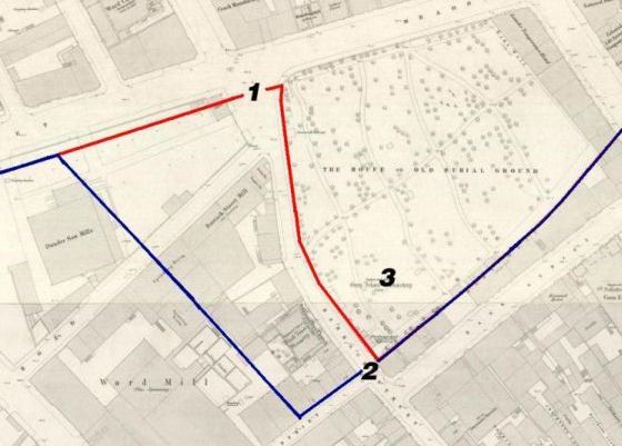
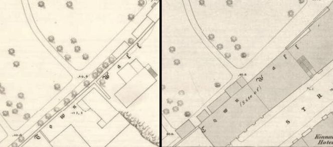
How the City walls changed in the area around the Howff.
Red: Presumed line of the 16th century walls.
Blue: Presumed line of the 17th Century walls.
1: Site of the 16th century port or gate.
2: Site of the 17th century port or gate.
3: Presumed site of the Grey Friars Monastery.
Source: Historic Dundee the archaeological implications of development, 1988.
Map section: Reproduced by permission of the National Library of Scotland.
The Howff or Houff is an old Scottish word for a meeting place and the cemetery
itself was the place where the Nine Incorporated Trades of Dundee gathered to
discuss their business.
The Crafts had originally held their meetings within the city churches, however
through time it became apparent that they had started to move into the burial
ground. The earliest mention of one of the Crafts holding a meeting in the
burial ground was by the bakers on the 30th September 1576. The crafts
themselves consisted of Bakers, Shoemaker, Glovers, Tailors, Fleshers, Hammermen,
Bonnetmakers, Weavers and Dyers.
In January 1581 an agreement was signed in the Howff, which united the Nine
Trades into one organisation. A good explanation of what went on at these
meetings is described best in this passage from Burgh Laws of Dundee with the
History, Statutes, & Proceedings of the Guild of Merchants by Alex J Warden. :-
"The individual Crafts had their special meeting places generally around a
tombstone, each apart from the others and the united Incorporation had also a
distinct section for their general meetings. For the privilege of holding their
meetings there the Crafts paid a yearly rent to the town. In the account of the
revenue of the town for the head roumes, Ł5 12s. When the Crafts met for the
transaction of general business, the subject was brought before the united body,
then the individual Trades went each to their separate meeting place to consider
the subject, after which they met again in common court, and each Deacon
reported the decision to their Trade, when the matter was then decided by the
majority.
It has been seen that when the union was formed among the Crafts a Collector was
chosen for the purpose of managing, in conjunction with the nine Deacons,
matters in common to the whole Crafts. It appears that he, as acting for behoof
of all, presided at meetings of the confederate body, and the he often acted as
arbiter of judge in disputes between members of the Crafts. He also collected
the unlaws or fines imposed upon the craftsmen, and disbursed the same as
instructed by the Deacons. The precise nature and extent of his entire duties
are unknown, but he must of been an important person among craftsmen, as he
takes precedence of the Deacons in the agreements for union which have been
given, and in other documents pertaining to individual Crafts. He seems to have
occupied a position somewhat analagous to that which is now held by the
Convener; indeed it is probable that the one title gave place to the other, or
rather to that of Deacon-Convener, which was afterwards changed to
Convener."
The north wall of the burial ground had a number of "fillets" in the wall. One
was noted directly opposite memorial 557 and had the words "This is the
Brabeners Head Roum" written upon it with another one "This is the Cordwainers
Head Roum" just to the east of it. It was noted that there were other "fillets",
however they were said to have been that badly effaced by erosion that nothing
could be deciphered from them. Another possible connection with the Crafts is a
passage of text on the north end of the west wall which is "SO SAL THE LORD BLIS THE IN AL THY
PROCEIDINGIS". An photograph of it can be seen
here.
Mr Peter Dron makes reference to the Trades in the Register of Tombs and
Monuments in Dundee Burial Ground, 1832.:-
"Previous to the erection of the Trades Hall each of the separate Trades had a
monument in the wall; and a tombstone upon which the Deacon sat when any meeting
of the corporation was held.
The Convener also had a stone, upon which he perched himself when presiding at
general meetings of the Nine Trades. But as these monuments and stones were upon
the north wall they have been removed and the Bakers and Glovers are now all
that remains as the records of the past."
It is said that the area at the west end had been used for the meetings as the
main interments were carried out mostly at that side of the ground with the east
end being documented as being used for grazing cattle. This is also supported by
the 1832 plan of the cemetery which shows the vast majority of older large tombs
being at the western end.
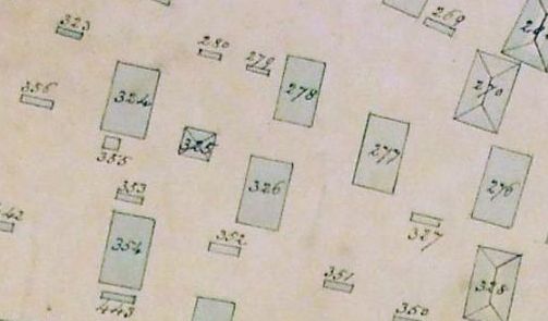
A Section from the Plan of the Burying Ground, Dundee,
1832, showing No.355
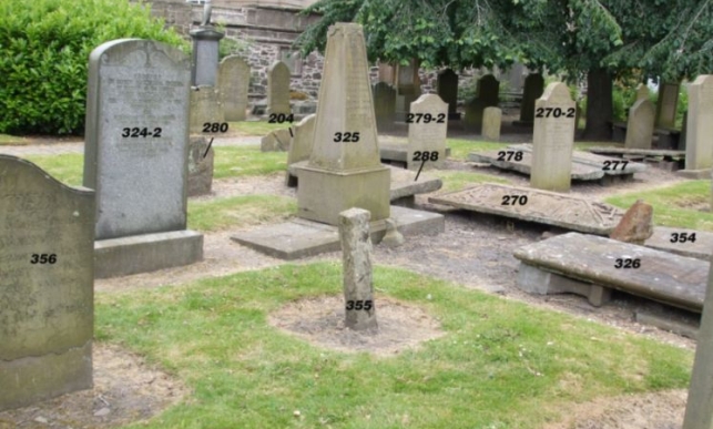
The "stone" in question that the Convener sat on is believed to be monument No.355, and I say monument as
the stone pillar was noted in the volume Dundee Delineated 1822, also by James Thomson in 1832
as having an inscription. This being:-
East side: William Renney, north side: Janet Alison, west side:
Arthur Wemyss, south side: Matildy Renney. And a year of 1042.
Indeed the stone itself has a claimant in the above register being Claimant:
Allison Wymss, David Hutcheson Grocer, Family of Thomas Wymss.
Note: Number 324-2 is a replacement for the table
monument 324 on the above map. The position of 356, 325 and 326 has remained
relatively unchanged.
Over the passage of time the association between the Trades and the stone
appears to have been lost, as due to having the supposed date of 1042 a further
story surrounding it appeared and was documented in 1832, this being that in
1807 Alex Christie who was the Town Mason perpetrated a hoax by removing
part of a stair from the "Vault", "dressing it in a peculiar fashion and placing
it in the ground". James Thomson referred to it in this quote, "if it is to
be considered a monument at all, must be considered as a monument of ignorance,
erected by a foolish tradesman in the nineteenth century in commemoration of his
own absurdity". My personal opinion is that it wouldn't be unreasonable to
assume that perhaps he did play a prank by carving the number 1042 into the
masonry.
Looking at the stone itself, which is now blank and slowly eroding away it can
still be seen as having a slight curve to the top and is roughly about the right
height for sitting on. I will however leave the gathered information and let you
the reader make up your own mind. One thing the evidence does do is dispel a
modern myth that it has any connection with Grissell Jaffray who was accused
then burnt as a witch in 1669.
In 1771,the shambles and tenements on the west side of it, were
bought by the Nine Incorporated Trades and a new hall was constructed with each
trade having a separate room to conduct their business. On 24th September 1776
the Trades assembled within the Howff for the last time before marching to the
Trades Hall led by Convener William Bisset.
Coming back to discussing the walls, by the early ninetieth century the walls
were becoming weakened and unstable and architect David Neave had submitted
plans for a new wall and railings at Meadowside in 1828, part of this plan was
to add a curve to the wall at the north west end of the ground. During
dismantling of the north wall monument number 192 was removed and rebuilt a few
feet south of its previous location free standing attached to some large pieces
of masonry.
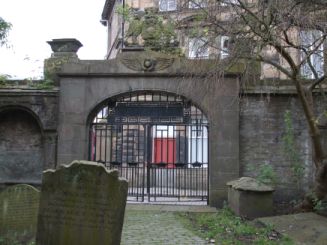
As part of the 1832-34 Improvement Plan which we will come back to shortly,
James Black who became the towns architect in 1833 designed and built the
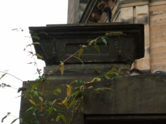
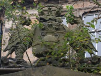
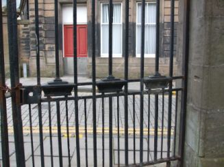
Barrack Street gateway to the Howff in 1833-34, The gateway itself has some nice
features including the Dundee coat of arms above, two caskets on top of the
posts and some miniature caskets incorporated into the bars.
The west central gate.
Casket on gate post.
Coat of
arms.
A section of gate
showing the miniature caskets.
During the installation of the gateway the west wall was partly dismantled
and strengthened and a number of monuments were either rebuilt or destroyed by
this process. When rebuilt the wall had the
current arcading added north and south of the central gate, previous to this the recesses were square in profile.
A few of the square recesses still remain which suggests these sections are as
built with a large section either side of the central gate being reconstructed
with the now familiar arches and decorative pillars being added.
Section from NLS towns maps showing the south wall. The
left image is from 1858 and the right is from 1870. Reproduced by permission of
the National Library of Scotland.
The south wall was taken down in 1864 when the Advertiser buildings were constructed on Bank
Street. A court case then ensued as the council had said that the plans were to
allow them to build up to the existing structure, however they proceeded to
dismantle it and build on its former footprint. The Towns architect assured
that building only took up a foot less space in depth than they were entitled
to. During this dismantling process the wall was noted as being nine and a half
feet tall and partially supporting the old wooden Dead House, this caused its
own fuss as when dismantling the wall it left the inside of the Dead House open
to the elements with a few letters of complaint being published in the local
newspapers at the time.
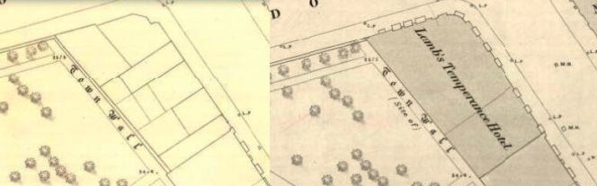
The east wall of the burial ground slowly started to disappear with the
construction of buildings on Reform Street with the last piece disappearing when
the Temperance Hotel was built at the northern most end, the building itself
still survives.
Section from NLS town maps showing the remainder of the east
wall. The left image is from 1858 and the right is from 1870. Reproduced by
permission of the National Library of Scotland.
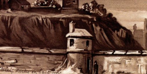
In the south east corner of the ground built into the wall was the watch house
which consisted of a small round building with windows and two doorways,
one which
opened into the Howff and another at the rear, it is shown to still exist in
1832 on the Howff burial plan disappearing sometime after this date.
A drawing of the watch house.
Source: A.C. Lamb: Dundee, Its Quaint and Historic Buildings,
image courtesy of Dundee City Archives.
An
interesting point to note is that previous to the Anatomy Act of 1832 the old
cemeteries, particularly the Howff and Logie were thought to be receiving a
great deal of attention from the resurrection men who supplied the Medical
School in Edinburgh with bodies for dissection and various other macabre
incidents about the graveyards roused so much alarm that over 3,600 men
volunteered to take turns in standing guard over the graves. The local
gravediggers were strongly suspected of taking part in this traffic, notably the
well known Geordie Mill, but no incriminating evidence was forthcoming.
Until 1821 there were no regulations with regard to removal or revising of
monuments within the Howff. Stones were frequently purloined both for the use as
monuments for other families via removal of their original inscriptions and
substituted by new ones, or for building purposes especially to top walls, one
in particular was the north wall of the Howff itself, some were used to line the
bottom of a washing canal in the Meadows while others were laid across it to
form bridges.
In 1832 Mr Peter Dron, Hospital Master, put into effect a plan to improve the
ground as by this time it was in a deplorable condition, being described as a an
area of neglected monuments in disarray with dark green over fed grass, black
clammy soil with humps and dips and very uneven ground.
The plan he put into effect was to move the memorials into more organised
parallel rows, this being especially so at the older western end, number the
memorials and keep a register of ownership of the monuments. This register can
be consulted today at the Dundee City Archive.
By 1820 the burial ground was already mentioned as being in an overcrowded state
in a previous account, and to alleviate this cart loads of soil were brought
into the ground during the improvements to bring the level up by as much as five
feet in places. This helped to both smooth out the dips and also allow for extra
burials to be carried out in those areas where the extra depth allowed this at
lairs previously considered as being full or almost full.
When the monuments were numbered initially, a painter was employed who proceeded
with numbering the stones, however he did them "as his fancy or caprice
directed" and the burial ground ended up being "a mass of confusion, duplicates
of the same number in some cases running up as high as to seven instances, all
which could easily have been avoided". These events were noted in 1838, which
suggests that the chiselled numbering was done after this date and has been
suggested to have occurred between 1838 and 1839. The duplicate numbering of the
monuments is explained by Peter Dron in his introduction to the Register of
Tombs and Monuments in Dundee Burial Ground, 1832. My personal view is that the
painter was stencilling the stones for the stone mason to follow and proceed
with cutting out the numbers on the monuments.
One of the carved numbers, normally on the southern edge.
Due to some of the memorials being moved some relatives of those interred began
to complain as their monuments placed over the graves of their loved ones were
no longer where they were supposed to be. Another problem which became apparent
with the shifting of lairs was that the Sextons, when digging for new interments
would strike the coffins and bodies of previous burials, sometimes in the
process amputating limbs or other body parts. This must have made a difficult
job even more distressing.
After the improvements had been completed the ground was a much more pleasant
place to visit and indeed was described in a newspaper article :-
"Not very many months have passed since, and its very aspect has been changed;
the ground is now as smooth, and the turf as green, as if it had slept for
centuries, dressed into the texture of a lawn by the sythe of the gardener;
shrubs and flowers wave as memorials of affection over those who sleep beneath,
and broad gravel walks, cut in every direction, prevent irreverent footsteps
from treading over the remains of the departed. The monuments which were
formerly huddled together in indescribable fashion, are now ranged in lines
parallel to each other, and numbered so as easy to be found". "The mode
taken to obtain it, was to cover the former surface of the ground with several
feet of new soil, so that the newly dug graves should not reach the depths of
the old; then to adjust the tomb-stones, and maintain, for the future, the
surface smooth and unundulating*, by carrying away the surplus earth of newly
filled up graves". *sic
Returning to the register there are a number of small stones in the burial
ground which contain only just a name or just initials and memorial numbers,
1363-1 being a good
example. The small stones were used as plot markers, when a family bought their
piece of ground these were used to indicate the piece of ground they had
purchased. Indeed the Register has entries as being "just a mark" at a later
date these have been removed and a proper monument has been put in their place.
It would appear that some families may not have had the means to furnish their
plot with a memorial and the markers still survive.
It has been observed that some of these markers were made from breaking up some
of the older tombs and likely is partly the reason there are no sign of a number
of them today.
During the numerous cholera epidemics that struck the city in the 19th century
the common practice was to bury the victims in large pits, mainly due to the
amount of fatalities from the disease and the need to bury them quickly. The
footpath at the south side of the burial ground is an area which was used for
this purpose. This quote is from the Peoples Journal published on the 12th
February 1916 and is by a John Brown who was 94 at the time :-
"One of my first visits to this city was over eighty years ago, when I was ten
years old. I saw the terrible effect of the cholera epidemic which was ravaging
the city at the time. I remember my aunt took me to the Old Howff to see where
they buried the victims. It was a terrible sight. There were long deep trenches
dug where the walks now are, and into these the bodies in coffins were heaped
unceremoniously. It was a regular plague the Cholera at that time, and the
drivers of the 'dead carts' used to go round the streets shouting "Bring out
your dead".
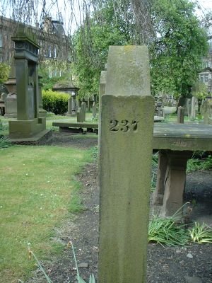
There is today one memorial, number 1451, easily located as it stands alone on the edge of the southern
footpath. It is
erected to William Forrest Esq who succumbed to cholera in 1832 and serves as a reminder of that terrible time.
By 1835 a new cemetery in Constitution Road was purchased by the town, and was
given the name New Howff. However during the twenty years following 14,250
persons had been buried in the Howff and by 1857 conditions had become so bad
that an application for closing was presented to the Sheriff of Forfarshire.
It was described as having "sights and smells of a disagreeable character
occurred at the opening of graves" and graves opened on the east side were
sometimes partly filled with oozings "curiously coloured, and very offensive to
more than one of the senses, etc etc". There are a number of articles regarding
this in the newspaper section of the website.
In spite of much opposition the Howff was ordered closed against general burial
from 5th November 1860. Below is the closure order for the burying ground :-
Order of the Queen in Council closing the "Howff"
At the court at Windsor, the 26th day of October 1860: Present- The Queen's most
excellent Majesty in Council.
Whereas, by the "Burial Ground (Scotland) Act, 1835," it is enacted that it
shall be lawful for her Majesty from time to time, by Order in Council, upon a
representation of one of her principle Secretaries of State that a copy of an
interlocutor of a Sheriff of a county in Scotland, under certain provisions of
the said Act, has been received by him, in pursuance thereof to order that no
new burial ground shall be opened within certain limits specified in such Order,
save with previous approval of one of such Secretaries of State ; or (as the
case may be), that after a time mentioned in the Order, burials within certain
limits, or in certain burial grounds of places of burial, shall be discontinued
wholly, or subject to any qualifications or exceptions mentioned in such Order,
and that such Order in Council shall thereupon have like force and effect as if
the same were embodied in the said Act : Provided always, that notice of such
representation, and of the time when it shall please her Majesty to order the
same to be taken into consideration by the Privy Council, shall be transmitted
to the Crown Agent in Edinburgh, and Sheriff-Clerk of the County in which such
burial ground is situate, and that the same shall be by them respectively
published in the Edinburgh Gazette, and fixed on the doors of, or on some other
conspicuous place within the parishes affected by such representation, one month
before such representation is so considered.
And whereas, the Right Honourable Sir George Cornewall Lewis, Bart., one of her
Majesty's principle Secretaries of State, has, under the provisions of the said
Act, made a representation stating, that he has received a copy of an
interlocutor pronounced by the Sheriff of the County of Forfar, finding that the
allegations contained in a petition of John Henderson and other (being ten or
more persons assessed to the relief of the poor of the parish of Dundee), that
the burial ground within the town of Dundee, commonly known as "the Howff," is
dangerous to health and offensive, have been proved ; and in the said
representation has recommended the issue of an Order of her Majesty in Council,
directing that burials should be forthwith discontinued in the said burial
ground.
And whereas, notice of the said representation, and of the time when it pleased
her Majesty to order the same to be taken into consideration by a committee of
the Lords of her Privy council, has been duly published in the Edinburgh
Gazette, and has been fixed as required by the said Act.
Now, therefore, her Majesty, by, and with, the advice of her Privy Council, is
pleased to order, and it is hereby ordered, that from and after the 5th day of
November next, burials be discontinued in the Burial Ground within the town of
Dundee, commonly known as "the Howff"
------------------------------------------------------
There were some exceptions to the closure however, Mr Richard Gardner Esq was
interred on the 3rd of June 1862 after special permission was received from the
Home Secretary. A required condition of the burial was that he be entombed in
the coffin surrounded by a cemented brick or stonework container, surrounded by
charcoal at least four inches thick and covered by a slab of stone.
His mother, Mrs Gardner was interred in the same plot,
839-2 on the 6th of September
1866.
The last person to be interred, also by special permission was George Duncan M.P.
who was interred in 1878, 265-2.
The west wall as it survives today looking
towards Meadowside.
Iain Flett and Innes Duffus giving a video tour of the Howff as part of the
450th Anniversary.